|

Myanmar's
Geography
Located
between Bangladesh and Thailand, with India and China to the north, Myanmar
covers an area of about 675,000 sq km (over 260,000 sq mi). The capital
and largest city is Yangon, an important trade center is Mandalay located in
central Myanmar.
The
country itself is divided into two classifications, Lower Myanmar and Upper
Myanmar. Lower Myanmar is comprised of coastal areas with thick tropical
forests that have valuable trees in them (teak forests, oil-bearing and timber
trees) with Upper Myanmar making up the interior parts of the
country.
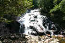
A
major topographical feature of Myanmar is the Irrawaddy River system.
Since its deltaic plains are very fertile, it is considered to be the most
important part of the country covering about 18,000 sq mi (47,000 sq km).
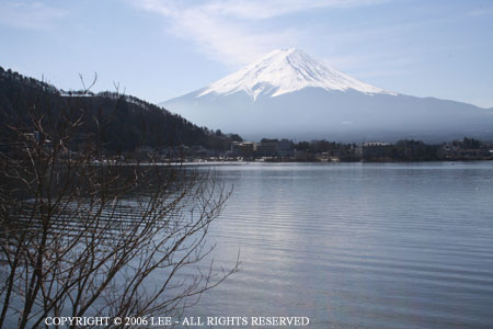
Hkakabo Razi, the highest peak in Southeast Asia at 19,295 ft (5,881 m), is
located in Myanmar. A barrier between India and Myanmar, the Arakan Yoma
range has peaks that range between 915 m (3,000 ft) and 1,525 m (5,000
ft).
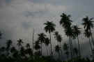
Almost
half of Myanmar is covered in forests that are comprised of teak, rubber,
cinchona, acacia, bamboo, ironwood, mangrove, coconut, betel palm with northern
highlands comprised of oak, pine and many varieties of rhododendron. There
are many tropical fruits to be found as well, citrus, bananas, mangoes, and
guavas in the coastal region.
|
Location:
|
|
Southeastern Asia, bordering the
Andaman Sea and the Bay of Bengal,
between Bangladesh and Thailand
|
|
|
Geographic coordinates:
|
|
22 00 N, 98 00 E
|
|
|
Map references:
|
|
Southeast Asia
|
|
|
Area:
|
|
total: 676,578
sq km
country
comparison to the world: 40
land: 653,508
sq km
water: 23,070
sq km
|
|
|
Area - comparative:
|
|
slightly smaller than Texas
|
|
|
Land boundaries:
|
|
total: 5,876
km
border countries: Bangladesh
193 km, China 2,185 km, India 1,463
km, Laos 235 km, Thailand 1,800 km
|
|
|
Coastline:
|
|
1,930 km
|
|
|
Maritime claims:
|
|
territorial sea: 12
nm
contiguous zone: 24
nm
exclusive economic zone: 200
nm
continental shelf: 200
nm or to the edge of the continental
margin
|
|
|
Climate:
|
|
tropical monsoon; cloudy, rainy, hot,
humid summers (southwest monsoon, June
to September); less cloudy, scant
rainfall, mild temperatures, lower
humidity during winter (northeast
monsoon, December to April)
|
|
|
Terrain:
|
|
central lowlands ringed by steep,
rugged highlands
|
|
|
Elevation extremes:
|
|
lowest point: Andaman
Sea 0 m
highest point: Hkakabo
Razi 5,881 m
|
|
|
Natural resources:
|
|
petroleum, timber, tin, antimony,
zinc, copper, tungsten, lead, coal,
marble, limestone, precious stones,
natural gas, hydropower
|
|
|
Land use:
|
|
arable land: 14.92%
permanent crops: 1.31%
other: 83.77%
(2005)
|
|
|
Irrigated land:
|
|
22,500 sq km (2008)
|
|
|
Total renewable water resources:
|
|
1,045.6 cu km (1999)
|
|
|
Freshwater withdrawal
(domestic/industrial/agricultural):
|
|
total: 33.23
cu km/yr (1%/1%/98%)
per capita: 658
cu m/yr (2000)
|
|
|
Natural hazards:
|
|
destructive earthquakes and cyclones;
flooding and landslides common during
rainy season (June to September);
periodic droughts
|
|
|
Environment - current issues:
|
|
deforestation; industrial pollution of
air, soil, and water; inadequate
sanitation and water treatment
contribute to disease
|
|
|
Environment - international
agreements:
|
|
party to: Biodiversity,
Climate Change, Climate Change-Kyoto
Protocol, Desertification, Endangered
Species, Law of the Sea, Ozone Layer
Protection, Ship Pollution, Tropical
Timber 83, Tropical Timber 94
signed, but not ratified: none
of the selected agreements
|
|
|
Geography - note:
|
|
strategic location near major Indian
Ocean shipping lanes
|
|
|
|
|
|