Map of
Nepal.
Nepal is of roughly
trapezoidal shape, 800 kilometres (497 mi) long and
200 kilometres (124 mi) wide, with an area of
147,181 km2 (56,827 sq mi). See
List of territories by size for the comparative size of
Nepal.
Nepal is commonly divided
into three physiographic areas: the Mountain, Hill,
Siwalik region and Terai Regions. These ecological belts
run east-west and are vertically intersected by Nepal's
major, north to south flowing river systems.
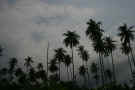
The southern lowland plains
or Terai bordering India are part of the northern
rim of the Indo-Gangetic plains. They were formed and are
fed by three major Himalayan rivers: the Kosi, the
Narayani, and the Karnali as well as smaller rivers rising
below the permanent snowline. This region has a
subtropical to tropical climate. The outermost range of
foothills called Shiwalik or Churia Range cresting at 700
to 1,000 metres (2,297 to 3,281 ft) marks the limit of the
Gangetic Plain, however broad, low valleys called Inner
Tarai (Bhitri Tarai Uptyaka) lie north of these foothills
in several places.

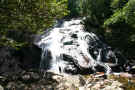
Gosainkunda
Lake in Langtang.
The Hill Region (Pahad)
abuts the mountains and varies from 800 to 4,000 metres
(2,625 to 13,123 ft) in altitude with progression from
subtropical climates below 1,200 metres (3,937 ft)
to alpine climates above 3,600 metres (11,811 ft).
The Mahabharat Lekh reaching 1,500 to 3,000 metres (4,921
to 9,843 ft) is the southern limit of this region, with
subtropical river valleys and "hills"
alternating to the north of this range. Population density
is high in valleys but notably less above 2,000 metres
(6,562 ft) and very low above 2,500 metres
(8,202 ft) where snow occasionally falls in winter.
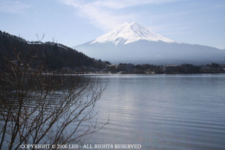
The Mountain Region
(Parbat), situated in the Great Himalayan Range,
makes up the northern part of Nepal. It contains the
highest elevations in the world including 8,848 metres
(29,029 ft) height Mount Everest (Sagarmatha
in Nepali) on the border with China. Seven other of the
world's eight thousand metre peaks are in Nepal or on its
border with China: Lhotse, Makalu, Cho Oyu, Kanchenjunga,
Dhaulagiri, Annapurna and Manaslu.

The arid and
barren Himalayan landscape.
Nepal has five climatic
zones, broadly corresponding to the altitudes. The
tropical and subtropical zones lie below 1,200 metres
(3,937 ft), the temperate zone 1,200 to 2,400 metres
(3,937 to 7,874 ft), the cold zone 2,400 to 3,600 metres
(7,874 to 11,811 ft), the subarctic zone 3,600 to 4,400
metres (11,811 to 14,436 ft), and the Arctic zone above
4,400 metres (14,436 ft).
Nepal experiences five
seasons: summer, monsoon, autumn, winter and spring. The
Himalaya blocks cold winds from Central Asia in the winter
and forms the northern limit of the monsoon wind patterns.
In a land once thickly forested, deforestation is a major
problem in all regions, with resulting erosion and
degradation of ecosystems.
Nepal is popular for
mountaineering, containing some of the highest and most
challenging mountains in the world, including Mount
Everest. Technically, the south-east ridge on the Nepali
side of the mountain is easier to climb; so, most climbers
prefer to trek to Everest through Nepal. Morever Nepal has
8 of the top 10 highest mountains of the world with
postcard beauty.
Neotectonics
The collision between the
Indian subcontinent and the Eurasian continent, which
started in Paleogene time and continues today, produced
the Himalaya and the Tibetan Plateau, a spectacular modern
example of the effects of plate tectonics. Nepal lies
completely within this collision zone, occupying the
central sector of the Himalayan arc, nearly one third of
the 2,400 km (1,500 mi)-long Himalayas.
The Indian plate continues
to move north relative to Asia at the rate of
approximately 50 mm (2.0 in) per year. Given the
great magnitudes of the blocks of the Earth's crust
involved, this is remarkably fast, about twice the speed
at which human fingernails grow. As the strong Indian
continental crust subducts beneath the relatively weak
Tibetan crust, it pushes up the Himalayan mountains. This
collision zone has accommodated huge amounts of crustal
shortening as the rock sequences slide one over another.
Erosion of the Himalayas is
a very important source of sediment, which flows via
several great rivers (the Indus to the Indian Ocean, and
the Ganges and Brahmaputra river system) to the Bay of
Bengal.
Environment
The dramatic differences in
elevation found in Nepal result in a variety of biomes,
from tropical savannas along the Indian border, to
subtropical broadleaf and coniferous forests in the Hill
Region, to temperate broadleaf and coniferous forests on
the slopes of the Himalaya, to montane grasslands and
shrublands and rock and ice at the highest elevations.
At the lowest elevations we
find the Terai-Duar savanna and grasslands ecoregion.
These form a mosaic with the Himalayan subtropical
broadleaf forests, which occur from 500 to 1,000 metres
(1,600 to 3,300 ft) and include the Inner Terai Valleys.
Himalayan subtropical pine forests occur between 1,000 and
2,000 metres (3,300 and 6,600 ft).
Above these elevations, the
biogeography of Nepal is generally divided from east to
west by the Gandaki River. Ecoregions to the east tend to
receive more precipitation and to be more species-rich.
Those to the west are drier with fewer species.
From 1,500 to 3,000 metres
(4,900 to 9,800 ft), we find temperate broadleaf forests:
the eastern and western Himalayan broadleaf forests. From
3,000 to 4,000 metres (9,800 to 13,000 ft) are the eastern
and western Himalayan subalpine conifer forests. To 5,500 metres
(18,000 ft) are the eastern and western Himalayan
alpine shrub and meadows.
|